This is the highest mountain in Vermont. Since I'm planning to do some hiking in the White Mountains of New Hampshire later this summer, and since most mountains of significance over that way are over 4000 feet, I thought it wise to try my hand (or should I say "feet") on a 4000 footer here in Vermont first. I tend to be very conservative about what I can accomplish physically, and so I was a bit worried that Mansfield would be too much for me. However, as it turned out, the climb was comfortably within my means.
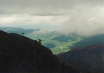
The weather today was excellent. We've had lots of hot, humid weather lately but the humidity broke and today was clear, warm but not too hot, and relatively dry. I certainly sweated as I climbed, but the breezes were comforting and the air felt clean. There were also some very nice views from the top.
I took the Long Trail out of Smuggler's Notch. The trail ascends up the side of the notch and more or less directly to the top of the mountain. It's only 2.3 miles to the summit from the parking area, but with 2793 feet of climbing it's a relatively tough 2.3 miles.
Smuggler's Notch is a rather impressive place. Vermont route 108 winds it's way among boulders through the narrow notch. There are signs lower down on the road that warn, "road closed to trailers." When you get into the notch, it's easy to see why. On either side of the notch there are steep cliffs. One day earlier this summer a friend of mine and I parked at the top of the notch and watched some rock climbers on the Mansfield side. It was a good opportunity to play with the telephoto lens.
The Long Trail ascends the notch a little lower down and so doesn't actually go up the rocky, cliffy part. Judging from the description in the guide book, the Hell Brook Trail is probably the one to use if you're into steep climbs. Many years ago, my brother and I ascended from the height of land in the notch to the summit of Mansfield using the Bear Pond Trail. It was one of the steepest climbs in New England that could be done without technical equipment. It was quite a trip! However, the trail is closed now from the road to Bear Pond (on the ridge). I remember reading someplace that the route was susceptable to avalanches and considered too dangerous.
Anyway, the Long Trail climbs steadily and seriously. Although it never gets particularly steep, it sustains a good grade without many pauses. This is definitely a trail where you need to pace yourself! The trail climbs through deciduous forests for quite some time before moving into a mostly spruce forest. Finally, at 1.7 miles (3650 feet), the trail reaches Taft Lodge. Up to this point there haven't been many views except for occasional glimpses of the ridge looming above the trees ahead.
Mt. Mansfield is interesting because when viewed from the East or West it resembles a face in profile that is looking up at the sky. The mountain is really a long ridge with several bumps marking the various portions of the face. For example, one of the bumps is called The Forehead, another is The Nose. There is also an Adam's Apple and even an Upper Lip and a Lower Lip. It happens that The Chin is the highest point on the ridge. (Doesn't everyone's chin stick out in front of their noses?)
From Taft Lodge you can ascend the Chin using either the Long Trail or the Profanity Trail. Despite it's intriguing name, I decided to avoid the Profanity Trail and continue on the Long Trail.
The trail continued it's steady climb and broke tree line just below the junction with the Hell Brook Trail (coming from the direction of the Adam's Apple). From there it climbed quite steeply over open, exposed rocks to the summit. You get some great views clinging to the side of the mountain! However, it's not a trail I would suggest trying in a high wind.
Actually, there was a stiff breeze blowing on the summit today and it was a bit chilly. I kicked myself for not bringing a proper wind breaker. I guess all the 90+ weather we've been having has kept me from thinking about being cold! I settled myself on the downwind side of the summit for lunch and, when the sun came out, I was comfortable enough.
There is a road up Mt. Mansfield. It goes to a parking area just below the Nose. However, from there it's a relatively easy 1 mile walk along the ridge to the Chin. Consequently there were quite a few people on the summit and many of them did not get there by climbing up from the bottom. That much was obvious from looking at them. However, the situation isn't as bad as it is on top of Mt. Washington because some hiking is still involved even for those who drove most of the way.
I decided to go down by way of the Profanity Trail. It was quite a neat trail! Although it didn't have the exposure of the Long Trail (better in bad weather), it did have some absolutely awesome views of the cliffs in Smuggler's Notch. Profanity dropped steeply and steadily. It hugged the base of a cliff, but felt like a long, steep staircase. I think it would be fun to go up this way sometime! Profanity returned to Taft Lodge and from there, I descended by way of the Long Trail to the parking area.
I had stiff muscles the next day, but otherwise the hike was not overly difficult. I was surprised that it only took me two hours to reach the summit; I had expected it to be longer for me. I think I'm ready for the White Mountains!
(Check out my climb of Mt. Moriah in New Hampshire done a few weeks later).
After a run of hot, humid weather it turned dry and cool today. I hiked with my friend, Laura. We decided to try the Hell Brook Trail that climbs out of Smuggler's Notch, leaving the west side of Rt. 108 just a little way below the height of land. The trail head was a little tricky to find. In fact, we drove right by it the first time. There was a sizable parking area there, mostly on the east side of the road, but there was no sign.
The trail climbed very steeply. It mostly stayed near a stream (I assume called Hell Brook), but it wound back and forth quite a bit. The stream was nearly empty of water—surprising considering all the rain we've had this year. It must be bone dry during August in a more typical year. Judging by the pitch of the land, I'd guess that this little stream has some very nice waterfalls on it in the spring.
Although the trail was quite steep and required a bit of scrambling here and there, it wasn't a particularly difficult or scary trail. The steep grades were all in well forested areas so there were plenty of tree trunks and tree roots to hold onto. There were interesting views of Smuggler's Notch from between the trees, but the trail was not an open cliff climb.
Eventually the trail reached the ridge and quickly came to Cloudland Notch. There the Bear Pond Trail branched to the right and the Adam's Apple Trail branched to the left. I found out afterward that Lake of the Clouds was only a short way down the Bear Pond Trail. If I had known that when we were up there, I would have stopped by!
We continued on the Hell Brook Trail. However, if I had it to do again, I would take the Adam's Apple Trail instead. That trail goes over the Adam's Apple, a low, open knoll of rock. It looked rather interesting and it would have been fun to climb up on top of it.
Today there were clouds blowing over the summit of the mountain, despite the sun shining in the valleys below. By the time we reached the junction with the Long Trail we were almost completely in clouds. The summit was windy, cloudy, and a bit cold.
Laura and I decided to take a different route down. We followed the Long Trail to the Profanity Trail and decended that way to Taft Lodge (which was being renovated by the Green Mountain Club). There we picked up the Long Trail again and followed that down to the road. We had to walk along Rt. 108 about a mile back to our car. It was a good loop—one that I would suggest to others.
While we were walking down from the summit, but still high up on the ridge of the mountain, the clouds lifted slightly and we were greeted with a spectacular view of The Nose ahead and below us. The late afternoon sun came out (it was about 5:00pm) and lit up the scene in a dramatic way. The clouds still played about the ridge, but the air was clear and clean down and away into the valleys. I had my camera but I didn't bother trying to capture the grandure of the view. Doing so was well beyond my skills.
It was a good hike with good company.
Return to the Vermont 100 highest list.